EGY_PDD: Egyptian Pavement Distress Dataset
Overview
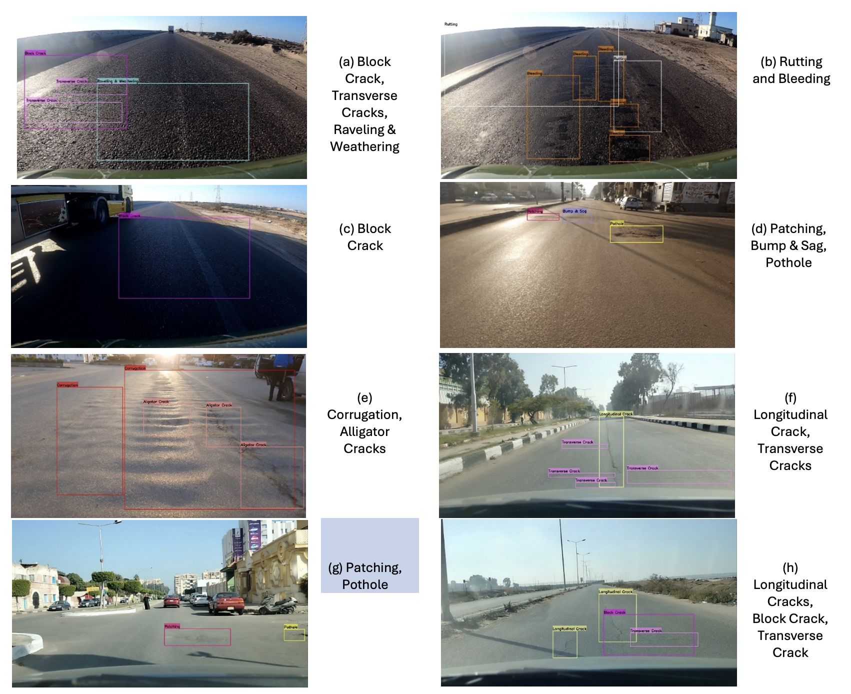
The EGY_PDD Dataset is a pioneering benchmark dataset specifically designed to address pavement distress detection and classification challenges in Egypt and the broader Middle East and North Africa (MENA) region. Featuring annotated 2D images and 3D road scenes, EGY_PDD facilitates the development of advanced machine learning models tailored to local pavement conditions. Road conditions in Egypt and MENA exhibit unique challenges due to specific climatic, geographical, and socioeconomic factors. EGY_PDD reflects these realities, making it an essential resource for robust and practical pavement condition assessment systems.
Key Features
• Comprehensive Data:
– Over 14,612 2D images annotated with 11 distinct pavement distress types.
– Includes 4,323 3D road scenes, enhancing distress severity analysis and enabling accurate calculation of metrics such as the Pavement Condition Index (PCI).
• Distress Categories:
– Classes include Rutting, Transverse Cracks, Block Cracks, Longitudinal Cracks, Alligator Cracks, Patches, Potholes, Bleeding, Corrugation, Raveling & Weathering, and Bumps & Sags.
• Localized Focus:
– Captures road images under diverse lighting, seasonal, and environmental conditions representative of Egypt and MENA.
• Dual Modality:
– 2D images for detection and classification tasks.
– 3D data for measuring distress severity and density using point cloud data (PCD) files.
• Real-World Challenges:
– Data includes extraneous objects, shadows, and varied textures, offering realistic challenges for computer vision models.
Dataset Composition
• 2D Dataset:
– Annotated in YOLO format.
– Images sourced from smartphone cameras, GoPro Hero 8, and Intel RealSense D455 depth camera.
– Provides bounding boxes for pavement distress categories.
• 3D Dataset:
– Includes RGB images, depth maps, and PCD files.
– Allows quantification of distress depth and severity using 3D geometry.
• Statistics:
– Class distribution reflects real-world frequency, ensuring model relevance.

Applications
EGY_PDD is designed to:
• Advance research in pavement distress detection and classification.
• Enhance road maintenance strategies in resource-constrained regions.
• Provide a benchmark for evaluating machine learning models on real-world road conditions.
Citation Policy
All papers, presentations, or publicly available materials that use the EGY_PDD dataset, whether in whole or in part (including compound or partial images), must cite the following publication:
Mohamed F. Abdel-Kader, Mohamed A. Hedeya, Eslam Samir, Ahmed A. El-Sharkawy, Rehab F. Abdel-Kader, Adel Moussa, and Emad El-Sayed. “EGY_PDD: A Comprehensive Multi-Sensor Benchmark Dataset for Accurate Pavement Distress Detection and Classification.”
Access the EGY_PDD Dataset
Due to restrictions from the funding agency, the EGY_PDD Dataset is available for academic purposes upon request.
Researchers interested in using EGY_PDD must follow the steps below:
How to Request Access:
1. Download the License Agreement:
– Click HERE to download the LICENSE AGREEMENT FILE.
2. Complete and Sign the Agreement:
– Fill out the required information and ensure the document is signed by an authorized individual.
3. Submit Your Request:
– Use the EGY_PDD Request Form to submit your application.
– Make sure to attach the completed and signed License Agreement file to the form.
Once submitted, your request will be reviewed by the authors, and you will be notified of the decision.